See clearly throughout Switzerland with the automated area of validity map
Together with Alliance SwissPass, we have developed a fully automated card solution that visualises the validity areas of public transport season tickets across all lines and transport companies throughout Switzerland in a precise, up-to-date and user-friendly manner.
«I appreciate the customer-oriented cooperation. Our concerns are always taken seriously, promptly reviewed and clarified, and responded to with a clear and solution-oriented proposal. Implementation is straightforward and always in the best interests of the customer.»
Karin Fankhauser, National Pricing, SBB (2025)
From static PDFs to dynamic maps
As frequent commuters on public transport, the General Abonnement (GA) makes everyday travel easier for many people. But is it really valid everywhere?
For more than 20 years, SBB has been producing so-called validity area maps in printed form or as PDF files. The desire to display more details on the maps was one of the drivers behind our digital validity area map project. In addition, PDF maps no longer met the requirements for digital information transfer. The most important reason for replacing the previous cards and the associated manual maintenance of content was the fact that the information on areas of validity was already available in other databases, where it was used as the basis for fare calculation and ticket sales, and where a great deal of energy had therefore already been invested in keeping it up to date.
NOVA-Daten als Fundament für eine neue Kartenlösung
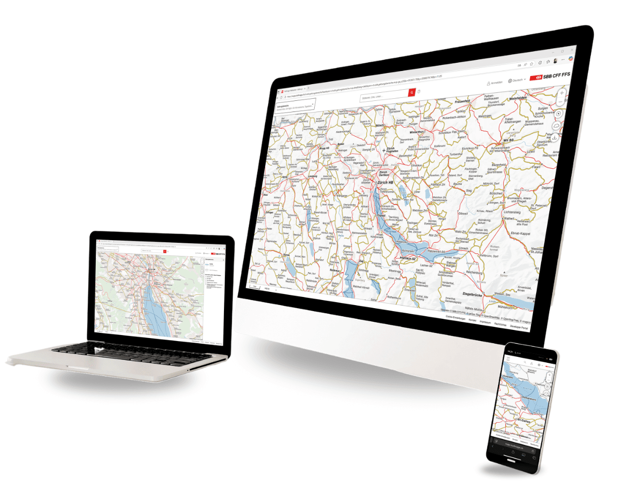
The areas of validity for the various travelcards are taken from the NOVA fare database, which is operated by SBB on behalf of the Federal Office of Transport. This central database provides all relevant fare information – from national rail routes to special regional connections. geOps uses this data to project it precisely onto the entire Swiss public transport network using its own routing tool. The resulting web map symbolises areas of validity in colour and makes them interactively queryable. Intelligent generalisation logic ensures that the display remains clear at national level and is also accurate down to the last detail at local level.
Data intelligence meets cartography
To make the complex subscription validity information from NOVA understandable and usable for everyone, geOps combines data expertise with precise cartography. At the heart of this is our topologically correct public transport network with detailed route lines and stops in various levels of generalisation. Using our specially developed routing engine, we generate precise line routes from the fare edges stored in NOVA, defined by start and end stops. Heuristics are also used to correctly display special cases such as different station numbers, airport buses or cross-border connections. This means that even minor differences, such as in the Jungfrau region or on tourist mountain railways, can be reliably mapped. For particularly complex cases, such as seasonal sports buses or directional restrictions on Lake Constance, the map deliberately uses neutral representations with corresponding notes. The result is an intelligent fusion of data modelling and map design that clearly visualises even complicated fare scenarios. Data integration and publication as vector tiles is fully automated with pipelines, allowing it to be updated several times a year.

Looking ahead: more features, more subscriptions, more clarity
The solution is already up and running and can be expanded with more subscription types, regions, or features. It creates a clear foundation for info and sales systems, as well as for end customers. At the same time, the project shows how complex data structures can be made understandable with smart tech and careful modelling. This approach can also be used in other markets and systems. At SBB, the map is integrated into several areas of the website. The map is also available independently on the Trafimage web map portal. In this version, the function for searching for stops and other locations is particularly practical. Other transport companies that want to use the map on their website can use the programming interface documented here.